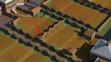
Structure 3 first appears in the 1856 engraving of the University of Virginia published by Bohn. It was depicted as a small rectangular building with a pyramidal roof, backing up against the garden’s southern serpentine wall and the central dividing wall. In the Anonymous 1870s map, even though the footprint of the structure is not shown, a water line arriving from the northwest and a drain line departing towards the east suggests that a structure was located there and that it was a privy. Privies were the most common type of outbuildings in the Academical Village, as they served everyone on Grounds. Their existence was recognized by the Maverick Plan as well as documented in the records of the University. For example, the Proctor approved a payment of $128.14 made for work completed on construction of privies by Peck and Crawford in the process of developing the Academical Village[1].
Structure 3 is depicted on the 1895 Sugino map, and measures approximately 7’ x 10’ with its long axis oriented north-south. Excavations conducted in 1960 by Donald Parker and in 2008 by Rivanna Archaeological Services were able to find remnants of this building. It is possible that Structure 3 was removed at the same time as Structure 2 (late 1800s to early 1900s), with the construction of the East Lawn Road that cut through the east gardens. University records show that privies were often vandalized by students and complained about by professors, so they were often rebuilt and relocated.
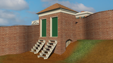
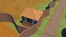
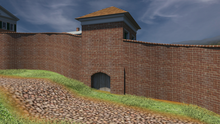
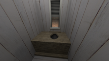
The digital reconstruction of Structure 3 is largely based on the privy replicas currently on Grounds erected by the Garden Club of Virginia in the mid-20th century, which used the Maverick Plan (although the privies depicted in that plan were never built). The digital reconstruction is also based on research as well as privies constructed at other Jeffersonian sites, such as Poplar Forest.
[1] Receipts folder, 1822. Proctor's Papers, University of Virginia Special Collections Library. Charlottesville, Virginia.
|
Aerial view of Structure 3 shows its... |
View of Structure 3 from Hotel D... |
Back of Structure 3 with ventilation... |
|
View of Structure 3 from Key Alley |
Interior view of Structure 3 |
